
Maps & Directions
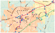 |
City of Auburn, AL Map |
 |
Auburn University Map |
From Atlanta, Ga.
Distance: 118 miles southwest of Atlanta (102 miles from the airport).
Time: Approximately 1.2 to 2 hours.
Directions: Take I-85 South out of Atlanta and travel 102-118 miles and exit the interstate at exit 51 and turn right. Then follow College Street into Auburn.
From Birmingham, Ala. (via Interstate)
Distance: 143 miles southeast of Birmingham.
Time: Approximately 2.2 hours.
Directions: Take I-65 South out of Birmingham and travel approximately 88 miles and exit the interstate onto I-85 North once in Montgomery which is exit 72. Then take I-85 North out of Montgomery and travel 55 miles and exit the interstate at exit 51. Then follow College Street into Auburn.
From Birmingham, Ala. (via US 280)
Distance: 115 miles southeast of Birmingham.
Time: Approximately 2 hours, but may take longer if traffic is heavy.
Directions: Take Highway US 280 East out of Birmingham and travel approximately 110 miles and exit onto Alabama Highway 147. There is a yellow blinking light at the exit. Travel down this road (College Street) five miles to downtown Auburn and the Auburn University Campus.
From Columbus, Ga.
Distance: 40 miles west of Columbus.
Time: Approximately 45 minutes.
Directions: Take Highway 280 West out of Columbus and travel approximately 30 miles and exit the highway onto I-85 South at exit 62. Then take I-85 South ten miles and exit the interstate at exit 51. Then follow College Street into Auburn.
From Montgomery, Ala.
Distance: 55 miles northeast of Montgomery.
Time: Approximately 1 hour.
Directions: Take I-85 North out of Montgomery and travel 55 miles and exit the interstate at exit 51. Then follow College Street into Auburn.
Last Updated:
Jan 31, 2014


![]()